Wednesday, April 28, 2010

WURLOS: The Gear

From WURLOS 2010

Almost as fun and almost as stressful as the skiing itself is gear selection. Equipment-wise, we were all on rando race setups. I was on Ski Trab World Cup Duo Race skis, Andy on Hagan Superlights, and Bart on Dynafit SR 11s. All of these skis are about 65 mm in the waist and around 160 cm long. They are less than 2 lbs per ski (around 800 grams) and all incorporate carbon fiber.

For bindings, we were all on Dynafit Low Tech Bindings. At 160 grams, built of titanium and aluminum, they are some of the lightest bindings available. One of the problems with the Low Tech bindings is that they do not have a high heel post. A higher heel post enables us to skin steeper lines, which is required by the WURLOS. We built our own heel lifters with some aluminum. With the yellow tab down, we had a medium heel post, and with the binding flipped around, we had a high heel post, which made steeper skinning much more comfortable and efficient.

From WURLOS 2010

For skins, I went with wall to wall mohair tail-less skins to conserve weight and to prevent glop. Bart was on some G3 nylon skins and Andy with BD nylons skins. All were wall-to-wall.

For poles, Bart and Andy went with double Whippets. I went with one Whippet and a Dynafit carbon pole, again to save weight and to be more efficient. In truth, there were a few times when I wished I had double Whippets. One of the issues I have with Whippets is that they are heavy. Bart and I are working on a lighter alternative.

For boots, we were all on Dynafit DNAs. Except for a few durability issues, we love the DNAs. They are comfortable and most importantly, they have a large range of ankle articulation, which makes for fast and efficient touring. And for the DH, they ski relatively well. Case in point: it's by go-to touring boot, no matter what ski I'm using. Dynafit is coming out the TLT 5 next year, which will change what is possible for a lot of ski tourers out there.

From WURLOS 2010

After our first attempt at the WURLOS, we had a good sense of what gear would be required and what we would not need.

From WURLOS 2010

Here is a list of what I carried:

1. CAMP Speed Helmet -- super light ski mountaineering helmet
2. OR lightweight beanie with the top cut off -- to save weight! Just kidding, for more ventilation.
3. Mont Bell Thermawrap -- super light and warm, awesome hood protects when weather turns bad
4. CREE LED light -- recommended by Kanyon Kris, puts out enough light for descents, best part: $20
5. Black Diamond Icon Headlamp
6. Smartwool lightweight top, scoopneck, women's model
7. CAMP X3 600 Pack -- super light at under 600 grams. It has a hip belt pocket and a ski carry system that allows you to put skis on your back without removing the pack.
8. carabiner -- to fasten skis to back, or to rappel off
9. Lowe Pro camera case with Canon S90
10. Closed Cell Foam Pad -- used to sit on during breaks and to wrap around ski bindings so they don't gouge my back
11. Patagonia wind shirt
12. Marmot thermal bottoms -- At about 11:00 pm at the top of the Pfeif, I stripped off my pants to get these on. It was worth it.
13. CAMP Water Bottle Holder
14. Pieps Freeride Beacon -- small and light
15. Dynafit ski pants aka tights
16. Lorpen spare socks
17. REI One spare gloves
18. Sunglasses
19. Leatherman
20. Blister care kit, containing Leuko tape, bandages, moleskin, and Dr. Scholls blister pads

Not pictured:
21. Camelback bladder
22. wool undershorts and undershirt
23. JETBOIL -- Andy brought a Jetboil to melt snow and cook ramen. It saved us big time. We ran out of water and the Jetboil brewed it quickly. 20 hrs into the tour, we stopped and had ramen noodles and it was a major luxury. On Monday, both Bart and I each ordered a Jetboil. I carried the fuel, Andy carried the stove, and Bart carried the noodles.
24. 20 meters of 5 mm cord. We didn't need it.

We didn't take shovels or probes. Nor did we take crampons, although we they would have come in handy in a few places.

That's probably more information than you wanted, but for future reference, it might come in handy for me.

For food, I took Brian Harder's advice, and took a lot of GU. Throughout the tour, I ate 15 GUs, 2 packages of Cliff Bloks, 2 Pro Bars, 2 granola bars, a bag of jerky, and 4 Snickers. For fluids, I drank Pepsi, water, Carbo Rocket, GU20 and Ultragen -- probably about 3-4 liters.

Monday, April 26, 2010

WURLOS: The Mountains

Well, Bart, Andy, and I more or less completed the Wasatch Ultimate Ridge Linkup On Skis (the "WURLOS"). For many reasons, the WURLOS didn't follow the path of the WURL as established by Jared Campbell, but there was a ridge linkup, it was in the Wasatch, in my mind it was "Ultimate," and I'm not aware of anyone who has completed a similar project, so, in keeping with and in honor of Jared C's label, I'm going to continue to call our path the "WURLOS." I'll dedicate this post to the mountains of the WURLOS, since it is the beauty and spirit of these mountains that fueled this project, and in the event others might want some beta about our path. Perhaps, in the future, I'll make some other WURLOS-related posts, like, what you think about during 21.5 hour tour, or why I dry heave when I see GU, or essential WURLOS equipment (or lack thereof), or how to cure to being afraid of vertical exposure, or how about, Making Sense of the Senseless? For now, the mountains . . . . Here is the route.

From WURLOS 2010

The primary objective of the WURLOS was to climb and ski many of the 11k+ peaks on the ridge splitting Big and Little Cottonwood Canyons, and on the ridge splitting Little Cottonwood Canyon and American Fork Canyon. The WURLOS route began at the "S Curves" in Big Cottonwood Canyon at about 6500 feet and climbed up Broads Fork. The Salt Lake Twin Peaks sit at the head of Broads Fork, and from there it was game on. Here are the peaks the WURLOS tags and skis:

1. SL Twin Peaks
2. Jepsen's Folly
3. O'Sullivan (Sunrise)
4. Dromedary
5. Monte Cristo
6. Superior
7. Baldy
8. Hidden Peak
9. AF Twin Peaks
10. Red Stack
11. Red Baldy
12. White Baldy
13. Pfeifferhorn
14. Chipman
** 15. Bighorn
** 16. Lone Peak

** We didn't tag or ski Bighorn or Lone Peak, but it can be done.

Here is a shot of the Big Cottonwood side (north facing) of Cottonwood Ridge, and the path we took.

From WURLOS 2010

From Twin to Superior is about 5 miles, but it is over some pretty rugged terrain. Here is a shot of the peaks that comprise what some call the "Triple Traverse" -- Twin, O'Sullivan, and Drom.

From WURLOS 2010

The descent of O'Sullivan's east ridge is a steep side slip.

From WURLOS 2010

To ascend Monte Cristo, we traversed into this cirque. I'm not sure if it has a name. Anyone?

From WURLOS 2010

And then ascended the Heart of Darkness. The Heart was filled with nice bootable snow. And at the top was a small little scramble to the top. No rope was needed to ascend.

From WURLOS 2010

A view of Monte Cristo from the North.

From WURLOS 2010

And then to Superior. It's hard to pass up the south face of Superior if you have skis, and it is a fast and direct way off the Cottonwood Ridge. Here is a shot of Superior's south face and an approximation of the line of our descent. We descended at about 1 pm in the afternoon. The conditions weren't ideal, but they were acceptable so long as we skied fast.

From WURLOS 2010

Here is a shot of the Cottonwood Ridge from the Little Cottonwood Canyon (south) side.

From WURLOS 2010

Superior's south facing apron practically dumps you into Snowbird. Having had issues with Alta, i.e., its intolerance for uphill traffic, we did not incorporate Devil's Castle or Sugarloaf. Instead, we began our ascent from Snowbird's tram dock, ascending up Chips Run to Baldy.

From WURLOS 2010

The east ridge leading up to the Twins is an aesthetic line.

From WURLOS 2010

From the AF Twins, the WURLOS tags and skis Red Stack, Red Baldy, White Baldy.

From WURLOS 2010

A close up of Red and White Baldy, along with our route for the day. Luckily, we were ascending in the evening, and the snow was hard, perfect for booting.

From WURLOS 2010

The Pfeif was in our sights before it got dark. By the time we got there, however, it was dark. We ascended by the light of the moon and LED.

From WURLOS 2010

And since the Pfeif is one of the icons of the Wasatch, a picture of the east ridge.

From WURLOS 2010

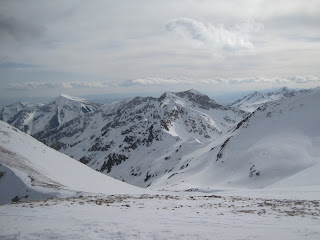
Here is a shot of the peaks and drainages west of the Pfeif.

From WURLOS 2010

And a shot looking at the Pfeif from Hogum Fork.

From WURLOS 2010

Getting out of Hogum Fork is always tricky. I like going up the north facing snow field, but it is also possible to go up the ridge (recommended if the snow isn't stable).

From WURLOS 2010

At the top of Hogum, Chipman awaits.

From WURLOS 2010

And from there, Big Horn and Lone Peak are within reach. Unfortunately, as we reached the "X" depicted below, we were exhausted, we lost all visibility, we were sketched out about ascending and descending Big Horn, and it was past midnight. So, we skied out Bells Canyon to our waiting car.

From WURLOS 2010

Looking down on Big Horn from the northwest.

From WURLOS 2010

The elusive but ever-inspiring Lone Peak. Maybe next year.

From WURLOS 2010

Sunday, April 25, 2010

The Line Has Been Drawn...WURLOS Over*

We played Pachinko again yesterday. We were gunning for a ski version of the WURL, a line drawn by Jared, that we then drew in our minds, and then drew with our tracks. We altered the original WURL, preferring major ski descents like Superior South Face over traversing Patsy Marly, and completely avoided Alta (because they aren't friendly to skiers).

The Line :

Start at S-Curves, up Broad's Fork, up Bonkers to Twin N. Ridge, ski Twin East Ridge, up Sunrise, ski Sunrise E. Ridge, up Dromedary, ski Drom E. Face, traverse above Sundial, ski an access couloir to Heart of Darkness, up Heart, up Monte Cristo N. Ridge, over to Superior, down South Face, to tram deck at Snowbird for gawks and laughs, up to Baldy (Jared only), Hidden Peak, AF Twins, Red Stack, up north facing couloir on Red Baldy, traverse ridge to White Baldy, ski NW Face down to ridge at head of Red Pine Drainage, traverse over to Pheiff, ski Southwest aspect of Pheiff, traverse down into Hogum, up to saddle between Lightning Ridge and Chipman, up and down Chipman N. Ridge, out Bell's Canyon to car.

There's an asterisk in the title because Jared's line included Big Horn Peak and Lone Peak. The WURL does too. But for now, the WURLOS is over, at least for me...at least for this year. I'll try to explain.

We dropped a car at Bell's, drove back over to the S-Curves, and were skinning at 5:22 AM. All of us felt energetic and positive relative to our first attempt. We skinned into Broad's with views of the high peaks as it was getting light and it was decided that the most direct line up the Twins would be to take Bonkers over to the North Ridge and go from there. I was wary of the new route because we'd been up the East Ridge twice, and knew what to expect.

Twin, N. Ridge in morning alpenglow

Jared thought the N. Ridge would be faster...and he was right, for him and Bart. They topped out marginally faster than the other way and had more fun on the new route.

Bart investigating glide cracks on Bonkers

Twin, N. Ridge

But for me, it took marginally longer with significantly more perceived effort. I looked at my watch as Jared topped out and arrived 7 minutes later. Bart had probably been there 15 minutes or more. I wallowed in rotten snow, post holing often. My early high spirits turned sour and I switched into survival mode for the rest of the day(s). I've been battling a cold all week and wonder if it contributed to my bewildering state of fatigue. Serious thoughts about bailing so as to not hinder the others were entering my mind early and often.

Nearing the summit of Dromedary

Jared was Jared. Fast, efficient, and brutal on the descents. He battled some allergies and seemed to have lost liters of fluids out of his nose, but was solid as always. And Bart, he was as strong as anyone I've ever seen in the mountains. He put in booter after booter, never complained, and let me follow all day. Jared would often surge to the front as well doing his fair share. Me? I led for maybe 25 steps over 21 hours.

Last attempt we dropped around the Sundial and then skinned up to Monte Cristo. This time we took a more direct line down this little couloir.

And then up the Heart.

Got a good look at the sky ramps, which could be incorporated into our line.

Jared topping out the Heart of Darkness.

A really difficult scramble through rock and rotten snow up the N. Ridge of Monte Cristo led to the summit.

Superior S. Face was great buttery skiing. We were worried it might be too hot and late in the day as Jared kicked off a small wet slide. Its OK though, his brother Sam says wet slides are nothing to worry about. In fact, Jared said not to bring avy gear at all since it was a spring time tour. He meant shovels and probes but Bart and I left it all. Not too comforting since we were setting off small but very manageable slides all morning in the new snow.

We were again, the butt of many jokes as we lounged around on the tram deck taking a break.

We got separated heading up Snowbird and Bart and I ended up waiting for Jared at the Warming Hut on Hidden Peak for quite a while. Eventually, Bart stepped outside and saw a lone figure on the summit of Baldy. We had figured that since both Baldy and the Twins were closed, we'd save our run in with the law for the big one that counted and went straight to Hidden Peak. Jared on the other hand, blasted covertly through the trees to the summit, to tag it for the group. Which brings up the topic of Snowbird policy and the ski patrol. Yesterday, they were cool as hell. They told us we could stay in the hut as long as we wanted even though they were closing soon, and that if we were leaving the resort, they couldn't care less where we went. Stark contrast to the skier hostile monsters at Alta.

Red Stack, Red Baldy, White Baldy, the Pheiff and beyond...long way to go still.

Looking back at Red Stack, Bart took the super cool ramp down the ridge.

We were losing daylight fast as we summited White Baldy. It was a beautiful crisp evening. Too bad I was losing my mind after 16 hours of exposed scrambling and skiing.

Nearing summit of White Baldy with Lone Peak way out in the distance.

A couple looks back at where we'd been.


In the waning light while crossing yet another knife edge ridge, I was pretty sure I'd try to make it up Chipman and then descend out Bell's and let the others go on to Big Horn and Lone unfettered. Pretty sure, but not sold. I brought it up with Jared and he just said, "Be Strong."

The moon was bright enough to cast a shadow, and sitting on the Pheifferhorn at 9:30 PM, the view was sublime. We donned our massive headlamps, and skied/traversed down into Hogum. While Bart was putting in yet another booter, clouds started creeping in and a few snowflakes drifted by. Chipman is a 15 minute ordeal, but in that time, the snow started falling harder and we noticed the summit of Lone Peak being engulfed by clouds. We traversed north seeking passage to Big Horn's East Ridge, and while doing so, became swallowed in clouds ourselves. The visibility went to near zero and my struggle to decide whether or not to continue became a moot point. Jared and Bart reluctantly gave up on the last two peaks but I have no doubt they could have continued on if the weather hadn't made scrambling around with thousands of feet of exposure too dangerous.

We stopped midway out Bell's to brew some ramen noodles and then limped out twenty one and a half hours after leaving the car. Making it possibly the longest single push without sleep I've done to date.

So did we do the WURLOS (Wasatch Ultimate Ridge Linkup on Skis)? I'm not sure. We did ski over 16,000 vertical and cover close to 30 miles while climbing and skiing some of the gnarliest terrain in the Wasatch. We linked up 13 named peaks over 11,000 feet, ate a lifetime's supply of Gu and Snicker's Bars, and learned a lot about what we can do on skis. As far as I know, this is the first time this line (an approximation of the Cottonwood Ridge and the Alpine Ridge linked, in a day) has been "completed" on skis. There's room for improvement in skiing the last two peaks, style (completely self supported except a snack and water at Snowbird), and the time it took. We could stay more on the ridge, tag more peaks, or do more descents. That's the beauty of Pachinko though, the only limits are one's imagination to see the lines and possibilities in the mountains.

WURLOS

Exiting Bells. Knees hurt.

Saturday, April 24, 2010

WURLOS

At Hidden Peak, going up Twins. Feeling ok and like we can do it. It's going to be a long night though.

WURLOS

Since its all about the up, we go up the Heart of Darkness to Monte Cristo.

WURLOS

Attempt 2. Twin.

Sunday, April 18, 2010

Terminal Cancer, Ruby Range

I saw a couple pictures a friend took while in NV this weekend and spontaneously decided to go on a little trip. I left SLC at 4:45 and made the boring, dark, solo drive to Elko, which is the launching off point to the Rubies. I planned on skiing the Terminal Cancer Couloir and nosing around a bit to see what else the place had to offer.

The Couloir looks imposing but the only difficulty lies in the narrow width that is sustained throughout. The hike from the car to the top of the couloir took about an hour.

Looking up from near the entrance
From the top
It's easy to drop off the other side from the notch at the top of the couloir and skin over to a small peak that offers great views of the range.

Easily day tripped, the Rubies make for a nice change of scenery to the Wasatch.

I made a super corny video filled with atrocious skiing that I'll post as soon I'm able to get it uploaded.

Saturday, April 17, 2010

WURL/Playing Pachinko, Part II

In my previous post I mostly talked about what we did. I think I’ll take some space now to mention what I think we could change and what I’d like to do next time. Also, I’ll steal some thoughts and words from Katsutaka Yokoyama, one of the peerless alpine climbing group, the Giri-Giri Boys from Japan. These are just my thoughts and don’t necessarily reflect Bart and Jared’s opinions, though I’d be interested to hear them after our disappointment settles a bit.

First, sleep, or rather a lack thereof, was a problem. Starting at 2 AM meant 1 AM wake up and 2ish hours of sleep for Jared and Bart. I made the mistake of napping on Thursday, thinking I might be able to sleep from 5 until after dark. I woke up at 6:30 and then wasn’t able to sleep at all after. I think a 5 AM start might make more sense in these winter/spring conditions especially since one of the technical cruxes is encountered early on. If thinking the whole thing might take 18 hours, we’d finish in the dark but should be starting more well rested.

Second, conditions were just OK. Waiting for the snow to settle to provide quick travel and easier skiing would save a lot of time and energy. And, would make toting around those crampons worthwhile.

Third, we carried too much water/food resulting in heavy packs. Too much, that is, if we plan on descending into Alta and climbing through Hidden Peak where provisions can be restocked. Which brings up some style issues. Should we go fully self supported? Have a car with a food cache at Alta? Fill water at Hidden Peak or bring a small stove to melt snow?

Last, and most important to me, is the route. We were trying to establish a winter version of the WURL, which stays entirely on the ridge from Broad Fork Twins, around the head of Little Cottonwood, and back along the ridge to Lone Peak. Because we are on skis, and want to incorporate some good descents it doesn’t make sense to stay on the ridgeline. Nor is that my goal.

This is where playing Pachinko comes in. Apparently Pachinko was a popular pin ball game in Japan in the 1970s full of erratic up and down movements on irregular trajectories. The Giri-Giri version of Pachinko is a linkup of multiple routes in the mountains. WURL stands for Wasatch ultimate ridge linkup and happens to go over all the peaks as a consequence. To do so it crosses through two ski resorts which when open, in my opinion pollutes the experience.

Yokoyama wrote, “Though climbers should leave no physical marks on a mountain, we like to believe our passion remains on the lines we draw. We want to follow the lines that only we can make out, that only we can climb….I realized that all of climbing is illogical. Because we live in a modern, rational world, the value of climbing increases with its irrationality. Pachinko – climbing up, coming back down, then repeating the process – has no rationale. It could be the answer to this age of advanced equipment, technical skills and information: Does our reliance on these means weaken our passion? If so, pick a mountain range. Open a map and trace a route, any route. When you do, you might see that we’ve only been playing on a portion of a mountain. The more you think about how to enjoy the mountain fully, the more possibilities you’ll discover. ”

Add skiing to climbing and it’s easy to watch the range grow as the possible linkups are much more plentiful than the lines themselves. I’d like to play this game again, but the most beautiful line to me would be a peak enchainment rather than a ridge traverse per se. It would include Twin, Sunrise, Dromedary, Monte Cristo, Superior, down to White Pine, up AF Twins, Red Stack, Red Baldy, White Baldy, Pheifferhorn, Chipman, South Thunder, North Thunder, Big Horn, Lone Peak. I would rather play Pachinko with the peaks outside the resort. This wouldn’t be the WURL and we’d lose a certain symmetry as well as Sugarload and Baldy from the experience. So what? They aren’t as aesthetic as the Thunders. And Lightening Ridge is far more beautiful than traversing above Alta.

Yokoyama talks about Ryoma Sakamoto, a nineteenth-century Japanese samurai and a Shi-Shi, a “man of inner resolution.” Yokoyama and a partner named an incredibly difficult route in Alaska Shi-Shi, to reflect that meaning. This route, in winter conditions will require self discovery that will push one’s limits. Who better to pioneer this particular peak enchainment than the SLC Samurai? (Not me, I’m the Sherpa who copied a blog name. But, I want to go along)

“I wanted to paint my way of living with the lines I climbed…In this world of boundless information, all you know for sure is what you see with your own eyes. But when you stand before a wall, you may have doubts. The act of climbing remains the only path a climber can trust. It is only when you act that you can truly see…Pachinko starts with a desire to keep climbing. And by continuously climbing, it takes on physical form. With fair weather, good luck and imagination, any modern climber should be able to discover his or her own Pachinko.”

-Katsutaka Yokoyama
Alpinist, Issue 26

WURLOS Post Mortem

Yesterday, I didn't like skiing and I was done for the year. But that's because I was in a bad mood. This morning I woke up after 12.5 hrs of sleep, and began thinking about another attempt at the WURLOS. Mood swings.

As I posted below, we abandoned our attempt at what we have called the "WURLOS" at about 3:00 pm yesterday. By that time, we had been going for 13 hrs, had climbed 12,000 feet, and our travels had taken us from the S Curves in Big Cottonwood, up Broads, to Salt Lake Twin Peaks, to O'Sullivan, to Dromedary, around Sundial, up upper Mill B, to Monte Cristo, to Superior, to Alta, under Devils Castle, to Sugarloaf, across and up Mineral Basin, to Hidden Peak at Snowbird.

The first 8 hrs of our foray went as planned and were "blessed."  We skied from the summits of 6 11k+ peaks on Cottonwood Ridge.  We met our self-imposed time checks.   We were confident.  We had a few good laughs.  At the top of Monte Cristo, I nearly fell off laughing when Andy turned around and looked at me.  One of the lenses on his sunglasses had fallen out or had never been there.  I asked, "what happened to your glasses?"  He said, "huh?"  And took them off and looked at them.  He hadn't even noticed that one lense was missing.

At Alta, we began an unrecoverable tail spin.  Looking back, there were several reasons underlying our abandonment.

  • Conditions.  Good coverage, hard surface/cold temps, and low avalanche danger would make a WURLOS possible.  It's hard to get these kind of conditions simultaneously.  Unfortunately, our travel surface, for the most part, was not ideal.  When we started at Broads at 6500k, I could easily sink my pole down to the ground.  Not good.  At about 9k and higher, the temps cooled down below freezing. However, the new snow that had fallen on Tuesday hadn't baked down yet, forming the dreaded breakable crust.  These conditions on both the ascent and descent slowed us down and sucked precious energy.  
  • Exhaustion.  Exhaustion is a given on a project like the WURLOS.  But I was surprised at how sapped I felt 10 hrs into the tour.  Where could I get the extra energy to go for 20 hours?  I don't know, but I think I could do a few things differently.  First, I wouldn't start at 2 a.m.  My body isn't used to skiing in the middle of the night, and I don't function well on 2.5 hours of sleep.  My partners kept telling me I was in a bad mood.  I wonder why.  It's not good to start a 20 hr push tired.  Second, I would take some planned rest stops.  We were on the march for 8 hours straight until we hit Alta.  Perhaps taking some time to rest and eat would have helped in the long run.  Beyond that, I don't know.  I guess I'll just have to man-up and pray a lot.
  • Gear.  For the most part, our gear choice was spot on.  Our ski and light setups worked perfectly.  I am confident I can ski any part of the WURLOS on race skis in the dark.  However, in our attempts to lighten up, our packs were too heavy.  I carried a lot more food and water than I needed to.   We didn't need crampons.  I think if I were to make another attempt, I would leave my avalanche safety gear at home -- no beacon, probe, or shovel.  
  • ALTA.  Alta doesn't allow any uphill traffic and they are sticklers.  No sweet talking.  No reasoning.  No nuthin.  Including Devils Castle, Sugarloaf, and Baldy in any route is more trouble than it's worth if Alta is open.  I can't say the same thing about Snowbird, because its employees are pretty reasonable when they meet uphillers.  That said, I was irritated when Snowbird wouldn't allow us to ascend the AF Twins.

Here are some pictures from our tour:

My food. I'm taking less next time, or caching it.

From April 17, 2010 (WURLOS)

Salt Lake Valley from Twin Peaks.

From April 17, 2010 (WURLOS)

Ascending O'Sullivan. Twin and an unnamed 11k peak in the background.

From April 17, 2010 (WURLOS)

Sunrise.

From April 17, 2010 (WURLOS)

Skiing of O'Sullivan's east ridge down to Tanner's saddle. Bart commented that he would take a steep sideslip over a 100 turn powder run any day any time.

From April 17, 2010 (WURLOS)

View of east ridge of O'Sullivan from Drom south face.

From April 17, 2010 (WURLOS)

Summit of Drom.

From April 17, 2010 (WURLOS)

We descended from Drom (where this photo was taken) to the Sundial (centerish in the photo). Miles of pure breakable crust!

From April 17, 2010 (WURLOS)

Perhaps on the next WURLOS attempt we will follow Cottonwood Ridge a bit further. Monte Cristo and the Heart of Darkness at the end of the ridge.

From April 17, 2010 (WURLOS)

Traversing between Monte Cristo and Superior.

From April 17, 2010 (WURLOS)

Will there be a "next time"? . . . .