Monday, June 7, 2010

Lurking Fear, El Capitan


Located on the far left of the Southwest face of El Capitan, Lurking Fear is perhaps the easiest route to the summit but offers less moderate free climbing and a bit more sustained aiding than it's more popular brothers like the Nose or Salathe.

Fatigued from thousands of miles in the car and nights on the ground we camped outside the park Sunday night at a dirt pullout off highway 140. Rolling into the park early Monday morning to try and secure a spot in Camp 4, Jason and I were rather unenthusiastic about the work ahead. Packing for a couple days on the wall, humping huge loads to the base of the climb, accustoming ourselves to the pace of climbing after so much skiing...it all seemed heavy and slow.

Our original plans had been to try and climb the Salathe wall and then just keep working away at the endless classics in the Valley. Big talk of multiple El Cap routes or long free climbs seemed to destined to be just that...big talk.

We settled on Lurking Fear as a "warm up" because it required relatively little mandatory free and Jason's ankle was still swollen and discolored from his awesome bouldering fall in Portland. Supertopo says fast parties fix to 3, fire the next day, and bivy on 10 and 17, topping out the morning of day three. Figuring we'd take our time to work out some of the big wall systems since I'd slighted Jason on my other big wall adventures and this was his first really aid intensive route, we planned on the full "fast party" 3 days. Water for two people for three days plus the descent is about 20 liters give or take depending on the temperature. Add that to a massive aid rack, portaledge, poop tube, bivy gear, etc, and you get packs in excess of 100 pounds. And to think Jared was complaining about a 16 pound pack, sheesh.

Well, after a rather apathetic start, we gained momentum and were soon established on the wall.

JD jugging up to the Pillar of Dispair, pitch 9

Views of the Cathedral Rocks in the long hours of early evening

View from our bedroom in the morning

View from the bathroom in the morning

The second day was pretty cruiser with the only hiccup being a short fall JD took right after this pic was taken

With two pitches to go and getting hungry for the summit as well as dinner, we pulled onto Thanksgiving Ledge, which has to be one of the coolest places in the world to spend a night just kicking it. We were ambivalent as to whether or not we should continue. In the end, food hunger won out and Jason was happy.


We feasted on canned peaches, Mountain House lasagna, soup, ramen, and dried fruit, and we were asleep before dark, tucked away in our little cave in the side of the cliff. We felt secure enough to unrope and take off our harnesses but did string all our gear along the entrance just in case we did roll a bit too far toward the cliff's edge.

The next day... Summit!

Psyched to be done climbing but my legs were sore for next 3 days from all that stuff.

Realizing that we'd have to take a couple rest days (and that I missed my cute wife) we drove through the night to get back to the comforts of home rather than stay in Camp 4. We are finishing up our rest period and tomorrow it's back to the road...

Friday, June 4, 2010

Volcano Tour 2010 Wrap Up

Our week in the Pacific Northwest was an overwhelming success in spite of the weather forecast that looked like: rain, rain, mostly sunny, rain, rain, rain, rain, rain.

A few quick stats:
  • 5 Ski Days
  • 35,000 vertical
  • 4 volcanos summited and skied (Adams, Rainier, Hood, Shasta)
  • 1 Thwarted Attempt on Mt. Baker due to nauseating whiteout conditions above 8,000'
  • 3,553 miles driven (with detour through Yosemite)
  • Surprisingly, only 3 meals at McDonald's
  • Eaten - one doughnut shaped like male genitalia from Voodoo Doughnuts in Portland
  • 1 sprained ankle
  • 3 stinky dudes

As posted previously, we managed Mt. Adams while all the other peaks were shrouded in clouds, and scored Rainier under splitter blue skies. I left SLC on May 21st and drove up to Portland where I picked up Jason and viking Lars who flew in from Indy and Denver respectively. We grabbed some groceries and drove out to the Adams' trail head which was conveniently located 5 miles from the real trail head due to lingering snow which kept the approach road closed. Sleeping at the roadside, we donned ski boots and were hiking "Teton Style" at 5 AM. Stupid. Anyway, 8,000 vertical later...

Lars finding his way back to the cloud deck


Sunday was a rest day as we drove up to Paradise on Rainier to secure permits and inquire about the weather/route conditions. We had planned on skiing the Emmon's Glacier, but the standard Ingraham Direct was "In" and had a much more convenient approach that still topped 9,000'. That night we ate at a sherpa restaurant, stayed at the Whittaker Bunk House, and then woke up at 2:00 AM. We were skinning from the car at 3:30 under clear skies and the thousands of vertical began ticking away.

Gorgeous morning


Looking back through Cadaver Gap toward Camp Muir, with Mt. Adams looming beyond
After a couple hours we began passing parties that had camped higher on the mountain. They were roped up as teams of 2-5+, hiking as slow as ants, unenlightened to the thought of snow travel eased by skis.

A look at the Ingraham Glacier with the route weaving through well bridged crevasses

We stood on the summit by 10 AM and were psyched to begin a 9,000' descent back to the car. The snow was variable but pockets of powder were still found up high. It's rare that one gets to feel like an absolute hero, but as we flew past the roped parties, mouths agape, we caught phrases here and there like, "BAD ASS!" Yeah, even though around most parts, we're nothing special, it felt pretty good to have our day in the sun.

JD on the Ingraham...about 8,000 ft to go


Viking Lars


Near the bottom of the Muir Snowfield, I was surprised as I went of a ~8 ft bank of snow and was suddenly air born. I thought I could control the landing but was immediately air born again as the embankment rolled off again steeply for another 8-10 feet. I bailed and summersaulted down to a stop just above a small rock outcropping. Happily unhurt, I yelled at the others not to follow and exchanged a coy glance with some rangers who were working on a nearby facility.

Thinking all was well I brushed off and tried to ski and immediately wrecked again. I quickly found out that the peg on my boot that locks the buckle into ski mode had completely snapped off, confirming in my mind that D.N.As are as others have reported, a bit fragile.
Back at the car before noon we immediately turned our thoughts toward Mt. Baker and pointed the car north. We drove up to the standard trailhead for the Easton Glacier and camped in a dirt pullout, setting up just as the rain came to a stop. Baker is another relatively big day at 7,500' and we were feeling a little less than motivated as we sat on the tarp at 5:30 AM cooking breakfast, listening to music from the car, and laughing at Lars' puffy face, swollen from sleeping head down slope with out a pillow.
The clouds were low lying but glimpses of the sun were caught intermittently so we were off again. Baker sits among the North Cascades which are absolutely stunning and offer an apparent eternity of steep skiing.


Around 8,000 ft, we hit the clouds and everything turned into a dangerous whiteout. Unable to discern up from down and only having a vague sense of where they summit lay, we did the only reasonable thing...fashioned a big pit to wait it out.


Unfortunately, the storm intensified and as we were unprepared, lacking wands and a map, we turned tail cursing Mt. Baker and the Pacific NW rain.

Still having fun though


A bit bummed about having our streak ruined, we headed back south, contemplating some interesting lines in the Tatoosh Range which while on Rainier look like mole hills but are super rugged and worthy little peaks.

Lane Peak with multiple striking couloirs. (Photo stolen from summitpost.org)

The rain, however, continued through the next day and the Tatoosh were not to be. So we went to Portland to stay with a friend and bouldered at a local gym where Jason rolled his ankle on the first problem of the day. $12 for a sprained ankle...good deal? Thinking flexy F1s would be more or less like an ankle brace, he sucked it up for the next day's objective, Mt. Hood.

On the drive up to Timberline Lodge, we were sure we'd get turned back again. Even the lifts were obscured by clouds and none of us had been on the mountain previously. Except this time we brought a couple secret weapons: a map, and about 300 wands (construction flags available at Home Depot, 100 for $7). We followed the lift line like braille and Jason gave us a 1 in 15 chance of making the summit. He'd be a terrible forecaster. After a snack, the clouds parted and the summit showed herself, completely coated in rime ice. We made a mad dash, dropping wands every 40-50 meters in case the ever threatening clouds moved back in.


A quick skin up the Hog's Back,


And a booter to the Pearly Gates,

led to some climbing through moderately steep rime ice and snow
and we found ourselves on the summit, again engulfed by clouds but thrilled at another summit and 5,400' of fun at our ski tips. On the way down, the clouds again parted and...

Blessed again.

We felt we'd stolen another peak from the weather gods, who must have had enough with our foolish/bold attempts because the next couple days the forecast (from the real forecasters, not Jason) was more rain...heavy rain. And, to complicate matters, the permits for Mt. St. Helens were sold out until the weekend. Ridiculous. Furthermore, the trail head for St. Helens starts at 2,700 ft or so, making the first few thousand ft of the climb on dirt and in the rain.

A meeting of the minds and a 100% guarantee (from Jason) that we'd have success prompted us to jump back in the car and drive 6 hrs south to Mt. Shasta. There was real appeal to this new plan because it would "guarantee" that we'd tag the 4 highest volcanoes giving the trip a nicer symmetry.

A 3:30 start put us in position to blow by all those on foot while still relatively low on the mountain. Again, we were the only ones on skis, and all the traditional "mountaineers" who had camped 3500 feet up, appeared utterly defeated as they stood knee deep in the new powder and watched us climb past. From that point on, we had the whole mountain to ourselves.

The morning was beautiful only in appearance. Savage winds scoured the mountain and nearly knocked us off our feet repeatedly. It was hardshells, zipped to the top, hoods on, type of weather.

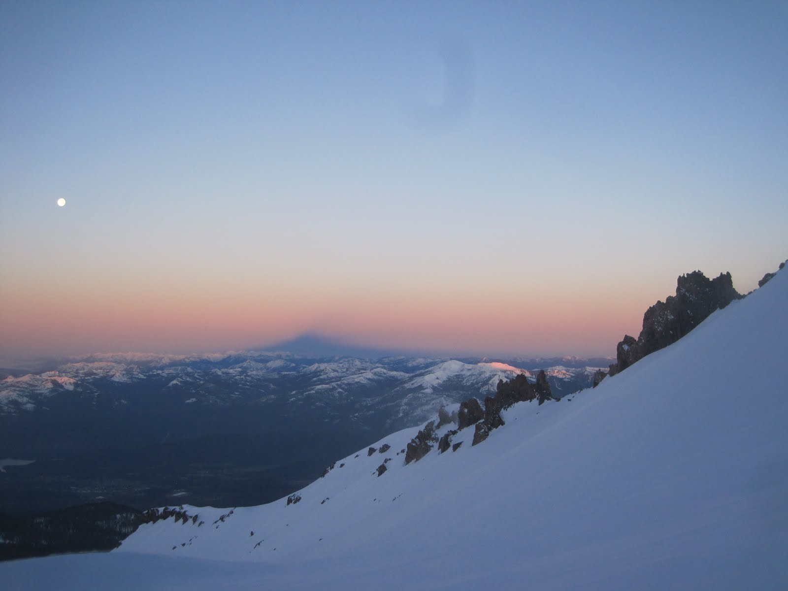
Shasta Shadow

Skinning toward the Heart. Our descent wound through some chutes in the center of the photo


Above Heart and heading for Misery Hill, just below the summit plateau. Winds WHIPPING (Video to come)
I didn't even pull out my camera on the summit because the wind was intolerable. Once in the lower chutes to the "left of Heart," we found some protection and undisturbed prime volcano powder.


JD

Jason's guarantee fulfilled

Victory

Volcano Tour...Over
Next up...Yosemite Valley

Tuesday, June 1, 2010

Highline Traverse: The Stats and the Route

Stats:

Distance: 59.7 miles.

Total Ascent: ?? My GPS and software won't accurately calculate this. . . grrrrrr.

Time: 38 hrs 16 minutes

Put in: Henry's Fork Campground

Take Out: Mirror Lake Highway, 4-5 miles below Hayden Pass

Partner: Brother Sam -- A tough dude who you wouldn't want to get in the cage with. He's forced me to tap out a couple times.

Ski Gear: Trab World Cup Duo Race w/ Dynafit Low Tech Bindings, Dynafit DyNA boots (me); Sam borrowed Bart's setup -- Dynafit SR 11s w/ Low Tech Bindings, Dynafit DyNA boots.

Other key Gear: CAMP X3 Pack, Jetboil, Mont Bell Thermawrap parka and pants, Mont Bell Tachyon windshirt and wind pants, Mont Bell spiral hugger sleeping bag, Thermarest pro lite pad.

Hrs. of Sleep: Not so much. The wind kept ripping off our sleeping bag and space blanket.

Miles left when toilet paper ran out: about 30

Wildlife seen: a grouse and a bobcat (did not eat)

No. of miles traveled with only 1 skin on: 10+


Okay, that's probably enough. Here are some illustrations of the route.

We started off at Henry's Fork Campground at about 5:00 am. We meant to get up earlier, but we slept in. At about 9000 feet, there wasn't much snow.

From 2010-06-02

Head of Henry's Fork.

From 2010-06-02

From the Henry's Fork Drainage, we climbed Gunsight Pass, and traversed and climbed Anderson Pass.

From 2010-06-02

Here is Sam on Anderson Pass at 12,700 feet. We didn't consider making a summit bid on King's Peak, which was easily within striking distance, because the winds were maching. I'd say about 80 mph. I was scared I was going to get blasted into the void, seriously.

From 2010-06-02

From Anderson Pass, we skied across a large valley, and headed toward Tungsten Pass.

From 2010-06-02

And from Tungsten Pass, we climbed to Porcupine Pass.

From 2010-06-02

We milked this slope for as long as we could. As you can see, the relief in the Uintas is BIG and BAD. Cliffs everywhere. Mountains in every direction.

From 2010-06-02

A little friend and a good omen.

From 2010-06-02

Once we climbed one pass, this is the view that often greeted us. Ummm, we have to go clear over there now?

From 2010-06-02

We got lost a couple times. The first time, we climbed midway up this cirque (the one in the far distance) before we figured out we were off route. Sam wanted to put me in a cage and give me a thrashing, but was a good sport.

From 2010-06-02

As the sun was setting, it peaked through as if to smile at us. See you in a few hours . . .

From 2010-06-02

Just as the sun is setting is a very peaceful time in the mountains. You have to enjoy it and remember it because once it gets dark, the mood changes.

From 2010-06-02

At 3:30 am, we were ascending Red Knob Pass. Skiing under a full moon was both eerie and comforting.

From 2010-06-02

When it got light, we were able to look back and see Red Knob Pass. Here is the view.

From 2010-06-02

And then we ascended Dead Horse Pass. Before we did that, however, we took an unintended detour. See the saddle on the right side of the picture below? We thought (or rather I) that was Dead Horse Pass, and climbed it, and skied off the other side of it. Once we were on the other side, we realized our mistake. It was 8:00 am and we had been skiing for 27 hours. Not a happy moment as we booted back up to the pass. Awesome terrain though.

From 2010-06-02

Getting back on route, we got a few turns in.

From 2010-06-02

Self portrait, frazzled and tired on Dead Horse Pass, with about 17 miles to go.

From 2010-06-02

At the bottom of Dead Horse Pass, this was the view that greeted us, with Rocky Sea Pass way off in the distance. It was about here that we ate our last ramen noodles.

From 2010-06-02

Here is Sam, ascending Rocky Sea Pass, with about 11-12 miles to go. Lucky for us, some snowmobilers had poached the pass (it's wilderness), and we used their tracks as an uptrack. Never have I been so grateful for poachers.

From 2010-06-02

And I didn't take anymore pictures after that . . . .

Special thanks to Mont Bell who provided much of the necessary equipment for the trip. Go Light and Fast!!!