Since running the Trans Zion earlier this year we've been talking about the rim to rim to rim. Schedules didn't work out for everyone but luckily Jared had Sunday afternoon and Monday off so we headed down for a quick trip. We worked out splits to make the round trip in under 10 hours. Our North to South goal was 4:20. After starting just after 7 AM we quickly ditched our jackets as the sun was getting hot, fast. The first section is a 5 mile down hill off the North Rim and down to the "caretaker cabin." We were expecting to move a bit quicker on this section but the trail was pretty steep in places and the footing not always very secure.
Jared off the N. Rim
More Jared
From the "cabin" it's a pretty nice low angle down for 8 miles to Phantom Ranch. We got back on schedule here but we both noticed that our legs felt fatigued. All the down was a little harder than expected.
Heading to Phantom Ranch, main branch of the GC in the distance
From Phantom Ranch we crossed the Colorado and had a 7 mile up hill to the South Rim. We thought we were ahead of schedule until we saw a sign that noted 3.5 mile to go, demoralizing. This was 3:30 into the day and were we slowing a bit. I looked at my watch and for a second it read a 25 min mile. If we kept that pace we'd top out at 5 hours and our hopes for a sub 10 hours trip would be over. It was warm and we were a bit tired but we both decided to go harder than comfortable in order to have a chance. Running past hordes of hikers we hit the rim at 4:20.50.
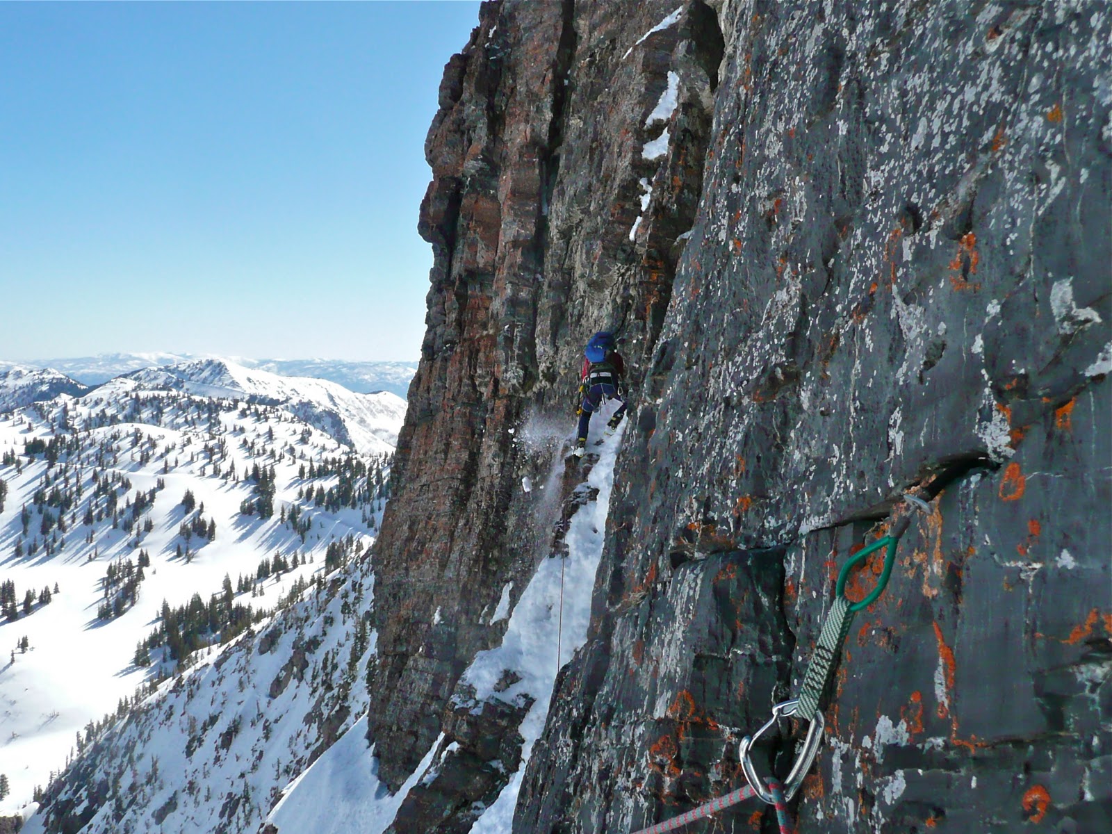
Up the S. Kaibab
View from close to the top
A quick water break at the top and we were back running. Jared's GI problems for the day started after eating wasabi/soy sauce almonds on the S. Rim. In retrospect, maybe not the best warm weather food... Back down to Phantom Ranch he was fighting dry heaves and over heating. Passing the trains of mules was ridiculous. We had to wait until they could pull off the trail and then slowly walk behind them hoping we didn't get kicked.
"Scariest part of the day."
S. Kaibab
Once down to the Colorado, we lounged in the water for a few minutes before starting the 8 mile low angle up hill to the "caretaker cabin." This is were the GI distress worsened. The 7 miles of dry heaves down to Phantom Ranch left Jared a little behind on nutrition, not a good place to be with 13 miles of up hill to go. We walked/shuffled the next 6 miles glad for the overcast skies and rain, the whole time hoping Jared's GI would settle and that he'd be able to put down some food and come back to life. With 7-8 miles to go it looked like we'd have to walk it out since Jared couldn't hold down food. He insisted I run it out and try to hit our goal. Feeling bad for leaving my partner (not bad enough to stay) but motivated to break 10, it was a very uncomfortable/hard effort for the next 2 hours. To make matters worse my watch died 8:10 into the day. I had the last big climb to do without knowing how close I was to the 10 hours mark. Knowing we started at 7:04AM I kept asking hikers for the time and going as hard as I could. 4:47PM once I hit the trailhead made the total time right around 9:45. Turns out after I left Jared he tried to drink a little Coke, 10 minutes later it came right back out. He had a rough last few hours but topped out just under 11 hours.
Afternoon rain on the N. Rim. Notice the bridge down low.
We left the N. Rim around 6 PM and then had a long drive home. Jared only vomited once in the car on the drive back, he managed to keep it in his mouth and get his window down only to spit it out all over the door, gross.
With the first dusting of snow in the high mountains last week, my thoughts are again turning toward falling snow, moving through rough terrain on skis, and some unfinished projects from last year. Jason and Adam have posted their top pics of the year and in an effort to boost my own already high level of psych for the coming season, I perused my photo library and found these 20+ favorites. Most have not been posted previously, and I tried not to duplicate any of the other guys, even though they already put up many of the best/favorites.
A September evening last year after climbing Squawstruck in Provo Canyon
JD sinking jams on the classic route, Triple Overhangs.
Just one month later, Adam was heading up Suicide Chute on a dreary early November afternoon.
Early December in the Selkirk Range, BC Canada.
Skinning through an old burn, about to enjoy 4,000 feet of Montana powder in Glacier NP. Photo by Jared
Just before Christmas 2010. JD on rappel in the NW Couloir of the Pfeifferhorn.
Jon Swain, the consummate powder whore, having some more for breakfast on Superior.
JD running in the new year in Zion NP.
A gang of stubborn skiers, refusing to lower ourselves to booting in the Memorial Couloirs, Mount Olympus. Photo by JD
First tracks in the Terminal Cancer Couloir, Ruby Mountains. Photo by JD
JD putting in a boot track in the TC.
Timp in late Winter conditions. Photo by JD
JD sneaking around the big mine, Oquirrh Mountains
Blustery winter day on the North Ridge of the Pfeiff. Photo by JD
Brian Harder in the Ford Couloir, Grand Teton
Trying to find my way around a melted out section of Cocietti's Ribbon in May. Photo by AOK
Brian Harder, traversing into the Black Ice Couloir, Grand Teton.
Corn below Mount Whitney. Photo by JD
Down climbing the Chevy Couloir in fat conditions, Grand Teton. Photo by JD
MLK rain crust at sunset in the Oquirrhs.
JD, dead pine, rime. Provo Peak
Smiley Viking rapping into the unknown. Pfeifferhorn
Sam and JD and rime. Mount Timpanogos
Dropping in to Lone Peak Cirque. Photo by JD
Zak Foy dropping a knee on a cold cold January morning.
Jared and JD marching onward. Somewhere in Hogum Fork.
That's it for now. More to come in a month or so when it starts snowing for real!
Also, the 28th to 30th of this month, the new Powderwhores movie, Breaking Trail, will be playing at Brewvies. I hear this year it's not all smelly tele. Can't wait!
My GPS tracks wherever I go. And it provides an accurate account of what I've done. Which is why it must be true that I climbed nearly every route (established and heretofore not established) on Lone Peak's summits, yes both of them, in about 4 hours. Here are my data points to prove it:
All the points I hit on Lone Peak in the span of about 4 hours.
I was on Lone Peak last week and saw a few parties on Center Thumb, since then I've been thinking about getting back. Jared had most of the day free and was psyched on doing a little climbing so after the saturday morning soccer games we were off. Our 11:15 start had us looking at nothing but clouds. When we finally got a view of the cirque we saw snow! Although the first snow of the season is exciting, snowy ledges/wet rock don't help climbing. To make matters worse clouds started to build and snow started falling the second we entered the cirque. We sat, shivered, and ate while trying to decide what to do. It came down to the good ole, "We might as well take a look."
Scattered damp holds and full on wet cracks made the first few pitches a bit more insecure than I would have liked. Luckily the sun came out and things seemed to dry out by the time we made it higher on the thumb. Turned out to be almost perfect climbing weather.
September snow clouds?
"My feet hurt." No, this face was not posed. Notice the snow.
Jared cruising the crux pitch
The late start had us summiting right when Jared had to be home. We skipped any further climbing plans for the day and had a quick jog out, GC training. Golden hour wasn't too shabby.
Last Saturday was the Midmountain Marathon in Park City. With all the real heavy hitters running the Wasatch 100 the day before or the Bear 100 later in the month, the MMM was still surprisingly well attended. Multiple friends and work colleagues participated and gave the start and finish areas a festive atmosphere. Everything in between was rubbish.
The race starts at Deer Valley and follows the MM trail to the Canyons, gaining 2500 vertical en route and losing a cumulative of 3700 feet. The trail is mostly beautifully runnable, albeit tortuous with switchbacks in places, but with very few rocky or steep sections.
The start was chill but I soon let a group of 5 or 6 gain a small advantage as my stomach was revolting for unknown reasons. As I watched them ascend, one switchback ahead, brother JD suddenly decided to quit toying with the field and made his move. One mile into the race, it was over. The next 25, he chased away boredom and cramps and won easily in 3 hours flat.
Newcomer and buddy, MS, ran a very respectable race and finished well in the top ten. After a pit stop in the bushes, I tried to get back in the race but never managed to reel anyone back in, finishing 10th. The pace was comfortable but the legs were heavy and still achy from other recent efforts. I think both rest and speedwork are underrated and would have done me a lot of good over the last few weeks. But, it's just too fun to find that freedom that the hills provide during all day creative efforts.
Congrats to JD for the MMM win and to all the W100 finishers. And, good luck to those about to do the Bear 100... Maybe one day. For now though, some rest is on the agenda. Starting to think about snow...
I'm fortunate enough to work with a few guys who like an adventure every now and again. In the past, we've done bike rides, marathons, Rim to Rim. Last week, our group set out to hike Mt. Whitney. Whitney is the tallest peak in the lower 48, and because of its popularity, to be in its vicinity requires winning a lottery and securing a backcountry permit. So, in the span of 56 hours, we flew to Vegas, drove to Lone Pine, CA, climbed Whitney, and then reversed the same.
Round 1: The Mountaineer's Route
My work group wanted a challenge beyond the more conventional Whitney Portal Trail, so we chose the Mountaineer's route, a route that ascends about 6,000 vertical in 6.5 miles. Much of the route is a Class 2 and 3 scramble. To those who are somewhat close to me, you should know that I was appointed the mountain guide for the day. That is because I am a mountain guide, just one that gets lost every now and again and lacks the certain inconsequential paper credentials. I committed that I would get the group to the top; after that, I had a plan of my own.
En route, we had a few odd diversions. While crossing over a ledge section in the early morning light, Barry broke into song:
The shenanigans diminished as we climbed higher and as the scenery became more serious. And soon, we were on the Mountaineer's Route. Most of the guys in the group didn't have a whole lot of climbing experience, but they persisted and at around 1 pm (and about 6.5 hrs of hiking), we stood on the top of Mt. Whitney.
The Mountaineer's Route goes up the saddle, and then to the top of the peak in the shadowed area. The lake (Icerberg Lake) was frozen on the top!
Josh, Barry, Jeremy, Nate, Sam and Joe (Barry's two sons) on the saddle, about to go up this:
Ice!
Round 2: The Whitney Portal Trail
At the top of Mt. Whitney the first time, I parted ways with my group and went back down the Mountaineer's Route. The rest of my group descended the 11 mile Whitney Portal Trail. Running down the steep Mountaineer's Route was a bit tedious and somewhat strenuous. I was back at the car about 1:45 after I left the top of Whitney.
At the car, I reloaded my pack with food, drink, and a headlamp. I left behind all the extra stuff, like my camera and jacket, which I later regretted. And then I headed back up the Whitney Portal Trail. It was 4:00 pm in the afternoon. At 8000 feet, it wasn't too hot, but slightly uncomfortable. I had been on my feet for almost 9 hours, and they had traveled 13 miles and 6000+ vertical over some pretty rugged terrain. I had a solid 22 miles and 6000+ vertical ahead of me. And Whitney looked like it was really really far away. And I almost became discouraged. I kind of wanted to just call it a day.
But then I took a sip of the warm Coke that I was holding. And I reasoned to myself that flying and driving 100s of miles and getting a permit to do 13 miles simply didn't make sense. And so I started jogging. I stopped thinking of where I wanted to go, and just focused on where I happened to be. Then I turned on my Ipod and was greeted by none other than Jon Bon Jovi. And from "Bad Medicine" on, everything made sense. All sense of tiredness, discouragement, and the cold I'd been nursing seemed to rest. And I ran.
As I ran, I watched my Garmin report a set of 15 minute miles, then a set of 20 minute miles, and then as I climbed above 12k, I had to walk, especially up the 99 or so switchbacks (that's not an exaggeration). At the top of the switchbacks, where the High Sierra and the John Muir Trails become one, a sign informed me that I had just entered Sequoia National Park. I wondered what it would be like to run or ski all or part of either of these trails, and was stopped short in my tracks as the Sierras -- all the way to Yosemite -- came into view. But, alas, no camera.
At this point, the euphoria of Coke, Bon Jovi, and Zen thinking began to wear off. It nearly completely dissipated as the summit of Whitney appeared waay waaay out there. Luckily, the 14k 2+ mile traverse to the summit is probably one of the most scenic in the US, and so it went relatively quickly.
About 3.5 hrs after I began Round 2, I stood on top of Mt. Whitney for the second time of the day. I hung out for a few minutes, talking with some French climbers who were spending the night at the summit. They had done a bit of rando racing in Europe and told me about some of their trail races. Of course, they mentioned the UTMB, something they obviously took pride in.
The 14k traverse was better in reverse. It was downhill and very runnable. And I happened to be running it just as the sun was setting, in the alpenglow. On the right, several thousand feet below me was a valley dotted with high alpine lakes, and beyond that was Sequoia and Yosemite. To left was a very steep granite face, huge spires and an occasional steep couloir; at the bottom was a glacial lake, and the lights of several backpackers.
Concerned that the temperature was dropping and that I wasn't carrying a jacket, I stopped to pick up someone's dropped glove. With a bit of trepidation, I sniffed it to make sure that was just a dropped glove, and hadn't been used for some other purpose. It didn't have that smell, but it smelled heavily of some deodorizer or fabric softener, which reminded me of the deodorizer used in Honey Buckets, and which, in turn, caused me to quickly drop it and risk 2 cold hands on the descent instead of just 1.
As I descended the 99 switchbacks, it got darker and darker, and then black. By then, my Ipod was pushing out some mellow baroque chorale pieces, but I shut it off and turned my head torch on so that I wouldn't run off a cliff. The darkness was a hindrance in descending, and I found that my downhill mile splits were about the same as my uphill mile splits. But other than that, I was in a good place mentally and physically. I was pleasantly surprised that it was about 10:00 p.m., I had been going all day, and that I was still running in the mountains with relative ease.
It was about that time that I encountered a backpacker, carrying a big backpack and an ice axe. When I approached he said,
"Man, am I glad to see you! I was seriously worried about you when I saw you coming up the switchbacks so late in the day. I had flashes in my mind about seeing a newspaper article about a dead Japanese tourist on Whitney, wearing just a t-shirt."
I laughed and apologized for causing him to worry.
"How far did you get?" he asked.
"Oh, I went to the top."
"I'm astounded. Really, I am."
And I suppose I should have let our conversation end there. But I didn't. The braggadocio in me spilled over, and I said, "And that was my second time."
"In your life, he asked?"
"Nope, today." He was very complimentary, and that felt good. We went on to talk about his trip and where he was from. And then I continued on.
The last 3 miles of the Whitney Portal Trail are pretty cruiser, even in the dark. After a small detour where I ran to Lone Pine lake and stumbled into some sleeping backpackers who pointed me in the right direction, I was able to open it up. My Garmin showed a 13 minute mile, then a 12 minute mile, then a 10 minute mile. And then, after 35 miles, nearly 13k vertical, and 16 hours on my feet, I was back at the Whitney Portal Trailhead.
Went out for a little WURL recon. Up White Pine to the Pfeiff, out the ridge to S. Thunder, Big Horn, Lone Peak, down to the "notch" and then out Bells.
A dry NW couloir of the Pfeifferhorn
Getting to South Thunder took a bit longer than expected. It was a little over an hour from the top of the Pfeiff. From there it's relatively easy to get up Bighorn. Finding the way off Bighorn and onto Lone was a bit of a search. There are two carains marking a gully that heads SW off the summit ridge of Bighorn. I heard that was the easiest way off the peak, definitely isn't. After a bit of down climbing I felt it was a little above my on-sight, down-climb solo comfort level. I turned around at a sand covered slab right above a pretty good drop off. I'm guessing it could be down climbed but it looked less than ideal. After that detour, I headed back to the ridge with hopes of following it out towards Lone. That's the way to do it. All you have to do is bounce back and forth from the south side of the ridge to the north side following the path of least resistance, backtracking when needed. No moves were harder than 4th or very easy 5th class.
A few moves before I aborted the gully
Once onto the shoulder of Lone it's not hard to find the way up. The summit ridge that leads down to the "notch" was easier than expected as was entering the notch. The gully down into Bells was loose but easy with a fair amount of hard snow in it. The Bells exit was overgrown, not too bad though. 6:56 total time was a steady pace but not fast. The WURL is BIG.